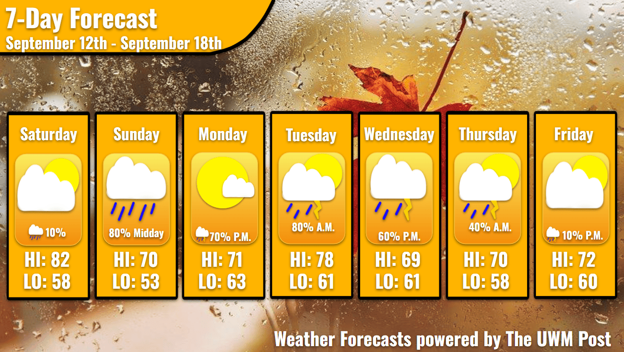
Overview: Milwaukee’s Weekend Weather Report September 12th, 2026, presents a peculiar pattern of storms which set up temperatures reaching down to the low-50s, but expect some substantial gusts.
This report looks at the weather over the next seven days. The forecaster offers a bit more detailed information about the weekend and more insight into what is happening with our weather.
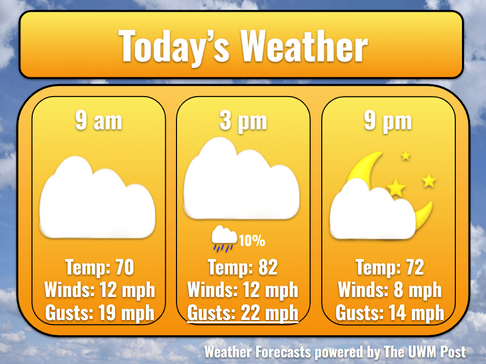
Today: Our morning begins with clouded skies announcing the arrival of the first storm system. Despite only producing a chance of showers today at 10 a.m. and 2-6 p.m., this low-pressure system splits northeast from a southwestern counterpart. The southwestern low sets up our Monday and Tuesday. At 9 a.m., temperatures sprint past 70 aided by 12-mph southwestern winds gusting up to 20 mph. In the afternoon, we hit a high of 82 under intermittent sunshine with winds now from the west. As gusts peak near 30 mph, temperatures cool off into the 70s for the evening. By sunset, clouds are scarce as we enter back into the low-70s.
Tonight: With a high-pressure system shoving in from the northwest, winds turn to the north overnight. They hold their speed around 8 mph with gusts near 15 mph. Cloudless in only a few moments during the night, temperatures quickly sink to 58 while the cooler air mass creeps closer.
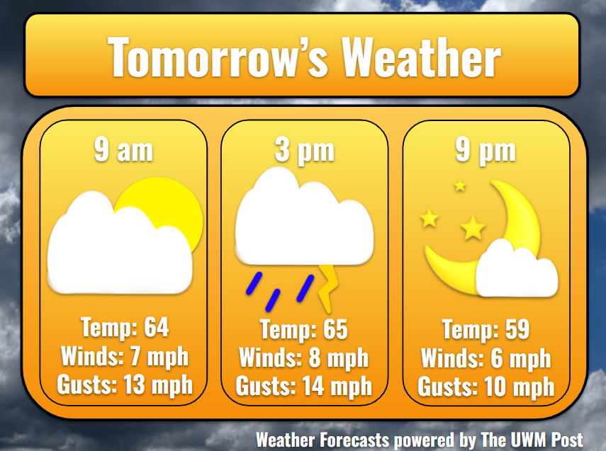
Tomorrow: Temperatures struggle to surpass 70 due to a midday storm. Gusting only to 20 mph, winds out of the west average 8 mph for most of the day. Upon the arrival of a west-moving thunderstorm around 11 a.m., winds shift to come from the northwest. This cold front sends temperatures down into the mid-60s for most of the afternoon. Once clouds sufficiently break apart in the evening, it’s too late for the temperatures to reach beyond 70 degrees. Milwaukee sees a tenth inch of rainfall on Sunday.
Tomorrow Night: Clouds thin out for sunset at 7:05 p.m. but still dapple the sky in oranges and pinks. Be ready for a dry night, cool temperatures, and a now friendly high pressure overhead. Our temperatures plummet to 53, below the average low temperature of 57. Meanwhile, dew points slump into the low-40s.
Monday: Deepening further, due in part to the enhanced subtropical jet stream of our current El Niño, the low-pressure system to our southwest grows in conjunction with another system over the Great Plains. These gain strength and begin to shove into the Midwest, increasing our winds. Averaging 12 mph over the whole day, winds start at 10 mph from the north in the morning, turn clockwise, then grow to 16 mph from the southeast by the evening. Though saving our temperatures from exceeding 71 degrees, winds off the 68-degree lake could even gust up to 35 mph. Precipitation is expected to enter in the night at 9 p.m., while the low-pressure system jogs northeast. Rain showers probably occur in isolated areas before midnight, but afterward, a more linear system of thunderstorms swings into Milwaukee.
Tuesday: Totaling roughly two tenths of an inch by noon on Tuesday, Milwaukee relaxes under cloudy skies for a moment. Southwestern winds slow to 8 mph by midday and calm by the afternoon. Even so, our high temperature still hits 78. As soon as the evening glow of the sun blankets Milwaukee, temperatures attempt a return to the 50s but only achieve a low of 61. Clouds frequent the night sky into Wednesday. Beyond Tuesday’s system, models begin to diverge in their stories. Stay updated with your weather this week due to this uncertainty!
Wednesday: A high-pressure system over North Dakota with a trailing counterpart over Montana drift eastward. Dependent on this system’s behavior, the predicted rain shifts. Expect a semi-cloudy morning with scattered showers later in the day. With these, some thunderstorms might develop overnight, but currently these stay to our south. Temperatures should hit near 69 degrees for a high. Due to winds around 8 mph off the lake, overnight temperatures don’t sink below 61. Gusts could reach 26 mph, so stay aware when driving.
Thursday: With the main portion of our precipitation chances within Thursday morning, Thursday afternoon stays dry. Temperatures stick around Wednesday’s high and top out around 70. Gusts remain around 30 mph, as 18-mph winds still track off the lake. Now, coming from a northern direction, it cools us to 58.
Friday: As winds begin to turn clockwise again, they slow to 6 mph with gusts only up to 21 mph. Temperatures gain slightly to peak at 72 thanks to the wind direction and partly sunny skies. Dropping to a low of 60 overnight, winds from the south signal a possible incoming storm, so stay tuned for more!