

Overview: Milwaukee’s Weekend Weather Report October 17th, 2026, witnesses the first frost of the season only to start warming up throughout the week to near 70 by Friday.
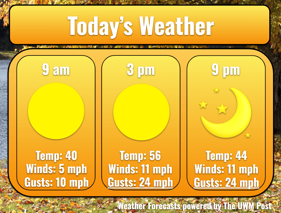
Today: If waking up around 7 a.m., many people feel the freeze as Milwaukee starts the day around 33 degrees. Temperatures warm quickly under full sunshine into the 50s during the morning to hit a high of 56 in the afternoon. Winds come out of the southwest at 11 mph with gusts below 25 mph. These slightly increase throughout the day due to a low-pressure system out west moving closer.
Tonight: A crisp clear night greets Wisconsin as a whole. Getting down to 40 degrees in the night, cozying up with a blanket or two sounds wonderful. Sadly, winds probably keep bonfires out of the question.
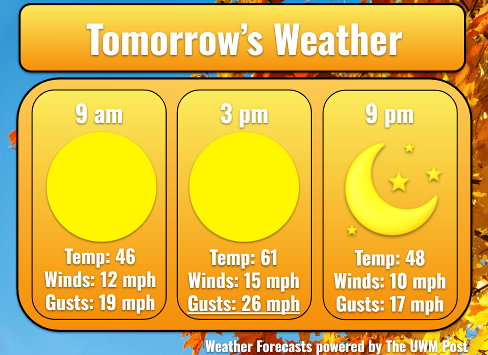
Tomorrow: Despite the nippy winds of 12 mph with gusts up to 35 mph, Sunday shapes up to be an average October day. Temperatures top out at 61 with the sunshine exaggerating the fall colors. Though still not yet at peak color, we are closing in on peak color as forecasted.
Tomorrow Night: Without a cloud in the sky, Milwaukee falls to 41 in the night. Winds finally calm down below 10 mph due to the low pressure tracking a bit more north.
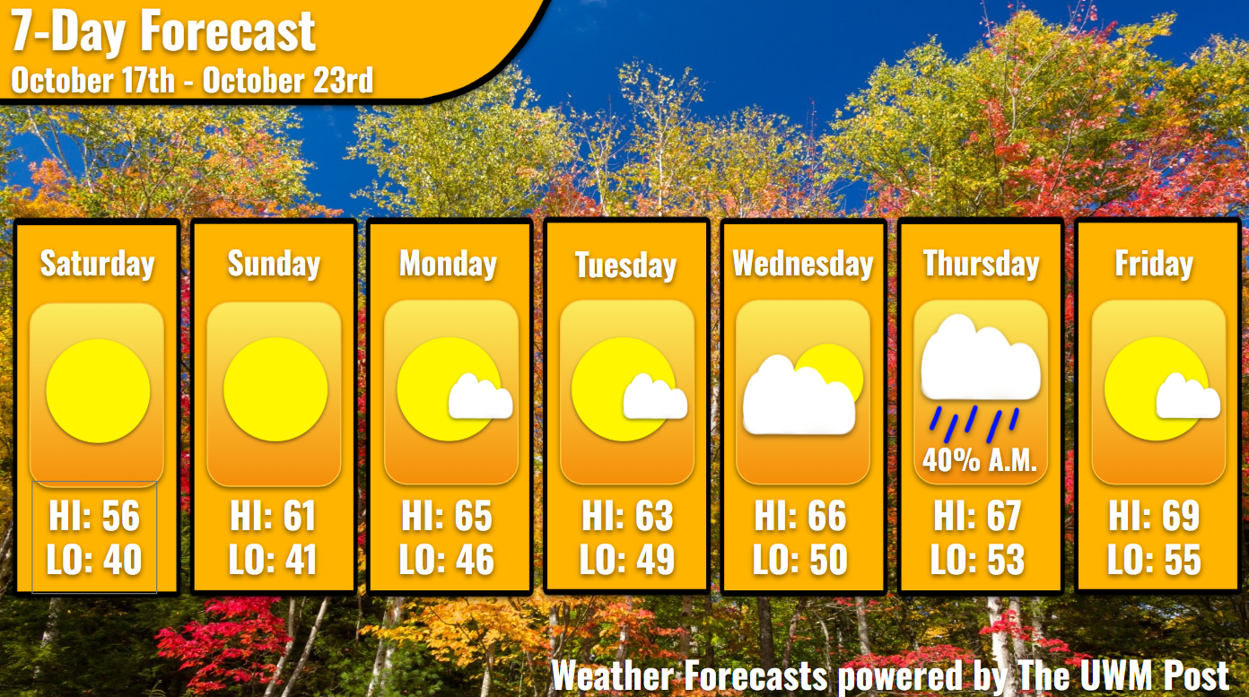
Monday: To begin the work week, a beautiful sunrise greets the chilly morning. Temperatures enter back into the mid-60s, as southwestern winds slow to 5 mph. Gusts seldom reach 18 mph. Getting into the evening, sparse clouds float across our skies. These clear up after nightfall. Temperatures drop to 46.
Tuesday: Once again, sunshine sends us into the 60s. Due to a southeastern wind of 6 mph, we only hit 63 in the afternoon. Gusts, however, do not rise above 15 mph. As we end Tuesday with partly cloudy skies, clouds linger through the night. Temperatures only drop to 46.
Extended: Over Wednesday, we continue to climb into the 60s, peaking out at 66 degrees. This is achieved with partly cloudy skies during the day. While the winds increase slightly from the south, clouds dominate in the night with possible rain into Thursday morning. Maximum accumulations reach a tenth of an inch so far. Otherwise, temperatures sink to 50 over Wednesday night before springing back into the upper 60s on Thursday. Temporarily, winds strengthen to 7 mph with gusts of 20 mph from the northeast. This switches overnight to the southeast, but not before temperatures drop to 53 Thursday night. Encouraged by the winds, temperatures near 70 with partly cloudy skies. Overnight, we only hit 55 degrees. Stay tuned for updates on the possible rain!
I really love how you explain every day it makes the week wiser to know how to plan the eeek