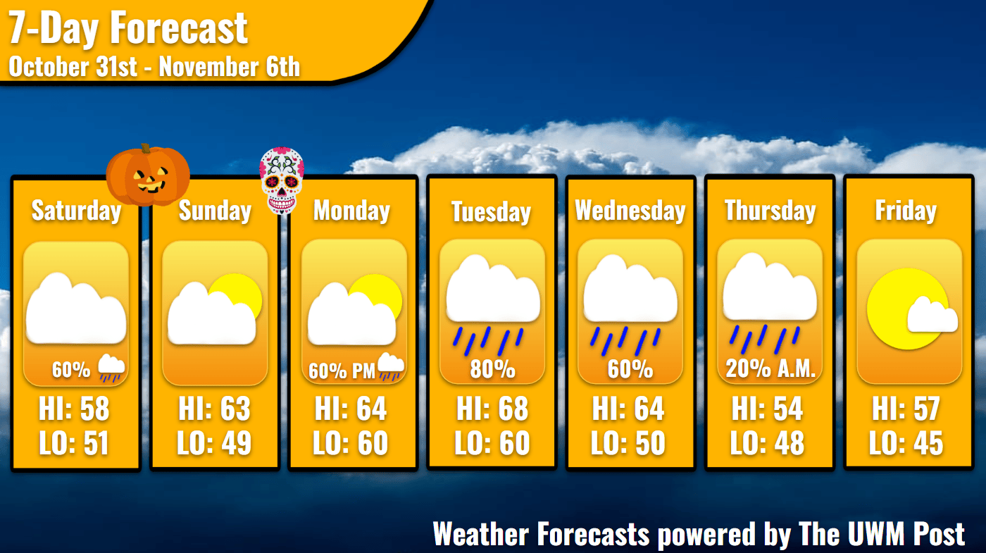
Overview: Milwaukee’s Weekend Weather Report October 31st, 2026, stars a high of 61 as trick-or-treating begins with a possible drip of rain. Warmer temperatures and rain come midweek.
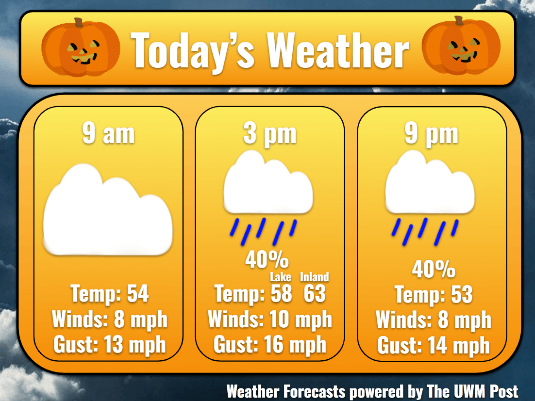
Today: Low clouds and light fog set a rather spooky backdrop for the beginning of October 31. Up to 54 by 9 a.m., fog dissipates and temperatures rise near 60 by the afternoon thanks to southeastern winds. Blowing at an average 8 mph during the day, gusts could reach 20 mph. Over the day, 7-9 a.m. and 3-8 p.m., some drizzles and showers could dampen candy-filled festivities, but these shouldn’t be much at all. Temperatures by 9 p.m. get down to 53.
Tonight: Overnight, a few more showers could present themselves as a trick, but hopefully Milwaukee is in for a treat of a dry rest of the night. We hit a low of 51 due to the winds, now at 5 mph. Another treat for the night is the possible extra hour of sleep. As we fall BACK an hour, when the clock strikes 2 a.m. on November 1, the clock turns instead to 1 a.m, thus beginning the potential extra hour of sleep.
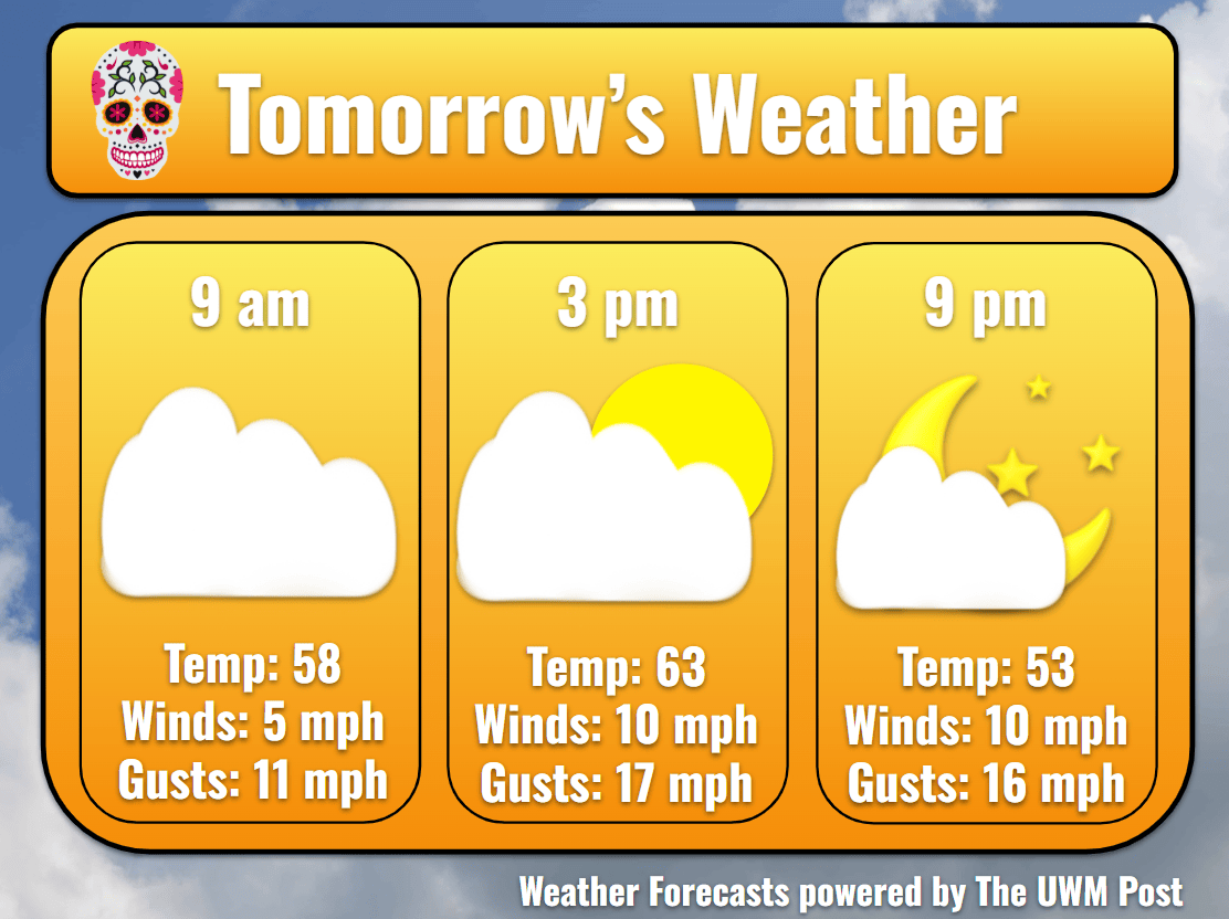
Tomorrow: In the early morning of Sunday, some light fog might float over Milwaukee. This lifts by 8 a.m. to reveal some breaking clouds. After October’s heat, the beginning of our November seems to follow its trend. For the first day of November, we might experience temperatures of 9 degrees above normal, as temperatures warm to 63 by 2 p.m. Winds stay out of the southeast at 10 mph for most of the day, occasionally gusting up to 19 mph.
Tomorrow Night: A dry night meets Milwaukee, as we brace for a potentially wet week. Scattered clouds dot the sky, while temperatures drop to 49 for a low. Increasing in the night, winds could get wild over the week. As a low pressure sets up to our west, the pressure difference across the state increases, consequently forcing winds to increase to 12 mph by the end of the night and 14 by midday on Monday.
Monday: As this happens, upper-level winds launch in from the southwest, sending in some high clouds. Temperatures get up to 64 aided by the strengthening southern winds. Clouds thicken and begin to wring out some rain over Southeastern Wisconsin by the afternoon. Accumulating around a tenth inch of rain, this warm front should pass by 8 p.m., inducing a temporary decrease in clouds. Still supported by the winds, temperatures remain around 60 for a low. However, the low pressure still tracks westward, ready to rain on our week.
Tuesday: Tuesday temperatures fly up to 68 degrees upon 15-mph winds from the south. Potentially gusting up to 40 mph, please stay up to date with your weather and stay safe. Drizzles start in the morning and pick up to a steady rain by nightfall. Models begin disagreeing on this system’s path by Monday night, thus significantly affecting the storm’s path on Tuesday and beyond. Due to this, rainfall could vary by location and time beyond this point in the forecast. Overnight, temperatures only reach 60.
Wednesday: Wednesday temperatures climb back to 64 before the cold air finally arrives behind the system. Winds still average 15 mph with gusts as high as 35 mph. The rain likely ends later Wednesday, despite possibly continuing into Thursday, after accumulating to an inch. Following this, winds change to come from the west. Taking advantage of the cool air, temperatures return to 50 for the nightly low.
Extended: Thursday becomes quite chilly after the cold front, as temperatures struggle to rise above 54. Holding a speed of 12 mph, cold northwestern winds could gust to 30 mph during the day. These calm into the night as temperatures sink to 48 under partly cloudy skies. Getting into Friday, models disagree even further on wind speed and direction, so keep up to date, but here is a possible forecast of how Friday could turn out. Temperatures rise slightly to 57 only to sink back to 45 overnight. Winds calm slightly but come from the northwest more. This pushes in cooler air ahead of the small high-pressure system dominating the northern Great Lakes region. Some clouds are expected.