Overview: Milwaukee’s Weekend Weather Report November 21st, 2026, sees one more summer-like day before rain announces the arrival of high 30-degree temperatures. Thanksgiving could see some interesting weather.
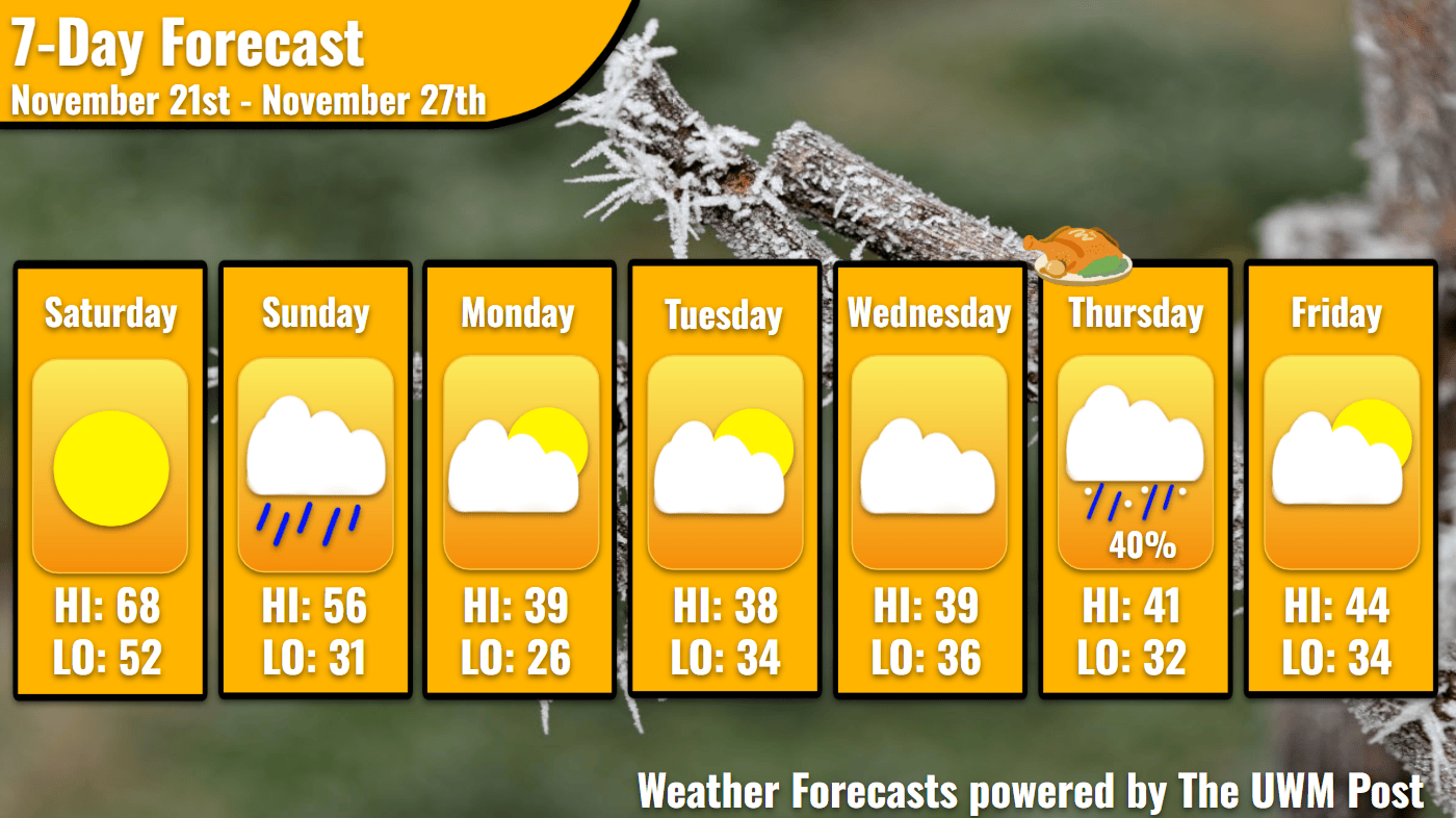
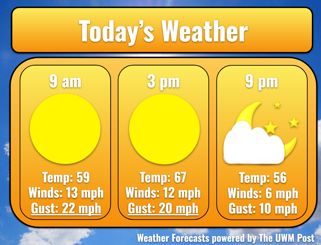
Today: Starting off a beautiful day, temperatures sprout back up into the 60s by 10 a.m. Winds blow in from the south at 15 mph, gusting up to 30 mph. Exercise caution while driving to minimize swerving. Thankfully, winds die down further into the day, sinking to 10 mph by sunset with gusts below 20 mph. Due to the northward movement of the warm southern air, Milwaukee’s temperatures hit 68 for a high. This would be two degrees cooler than the daily record high of 70 set in 1913. Yesterday, we did break the daily high record set in 1897 by one degree, hitting 67. Blue skies dominate the day, but pressures slowly drop.
Tonight: Despitea wind from the south at 9 mph, the sun sets at 4:23 p.m., taking with it some heat of the day. We sink down to the mid-50s by 9 p.m. and find ourselves under cloudy skies. Over the day, a low-pressure system tracked over Lake Superior and swung some cold air down behind. Northern Wisconsin accumulated a half inch of rain before the cold front passed during the day. Overnight however, the system’s line of storms from Southwestern to Northeastern Wisconsin makes its way toward Milwaukee. This does not near us until the early morning of Sunday. Some flashes of lightning are possible within the system before midnight. Eventually, our temperatures bottom out at 52.
Tomorrow: As the sun rises, black skies turn grey and finally begin to rain. Rain gauges measure up to two tenths of an inch before pushing out over Lake Michigan. While this happens, winds abruptly change to the northwest. Gusting up to 30 mph, these winds howl with the song of Jack Frost. We only hit a high of 56 due to the cold front’s passing at 11 a.m. Temperatures plunge into the high-40s by 3 p.m., just as the Northwoods begins seeing some snow flurries.
Tomorrow Night: The northern wind attempts to send these snowflakes southward but only succeeds in dropping our temperatures even more. As winds continue at 14 mph overnight, Milwaukee’s temperatures return to the low-30s.

Monday: Before we can break into the 20s, the sun’s rays warm us back up to 39 degrees. Milwaukee still fights the cold wind, though do winds calm down significantly by the afternoon. Broken clouds scatter in the evening, clearing out in time for Southeastern Wisconsin to witness the Super Beaver Moon readying to become completely full Tuesday morning. Our low is 26 degrees.
Tuesday: With minimal winds over the day, and gusts all below 20 mph, Tuesday seems nice. Fair-weather clouds dot the sky, and pressures increase. The drawback, for some, is the temperatures. Milwaukee barely rises to a high of 38. Some hope remains however, as winds begin to come off the lake overnight. With its water temperature in the mid-40s, Lake Michigan keeps the lakefront from freezing the next few nights. Our temperatures stick around 34 for a low.
Wednesday: School break starts on Wednesday, but students might despair, as we don’t have the temperatures of last week to enjoy. Milwaukee only sees a high of 39 with partly cloudy skies. Winds flow towards the west at an average 5 mph, occasionally gusting to 18 mph. As our high pressure moves eastward, a high-altitude wind stretches from South Dakota to the Southeastern United States. How future models resolve this will give better insight for our later-week weather. Currently, models show it pulling moisture from the East Coast and Gulf, straight over Lake Michigan into Wisconsin. Overnight, Milwaukee’s low is 36. Temperatures higher up sit below freezing. Dependent on the moisture content of the air, snowflakes may or may not form. A mix of snow and drizzles are expected from midnight into Thursday evening, but I will maintain a 40% chance for now. Stay tuned!
Extended: Past this event, Thanksgiving and Black Friday’s weather could be much different than the following forecast due to the divergence of models’ similarities. Temperatures hit 41 on Thursday with a low of 32. Blowing a bit faster than previous days, winds average 8 mph from the northeast, occasionally gusting to 20 mph. Clouds clear progressively until Friday receives a clear morning sky. Temperatures rise to 44 with a low of 34. Beyond Friday, there seems to be more unsettled weather, so stay tuned over the week!