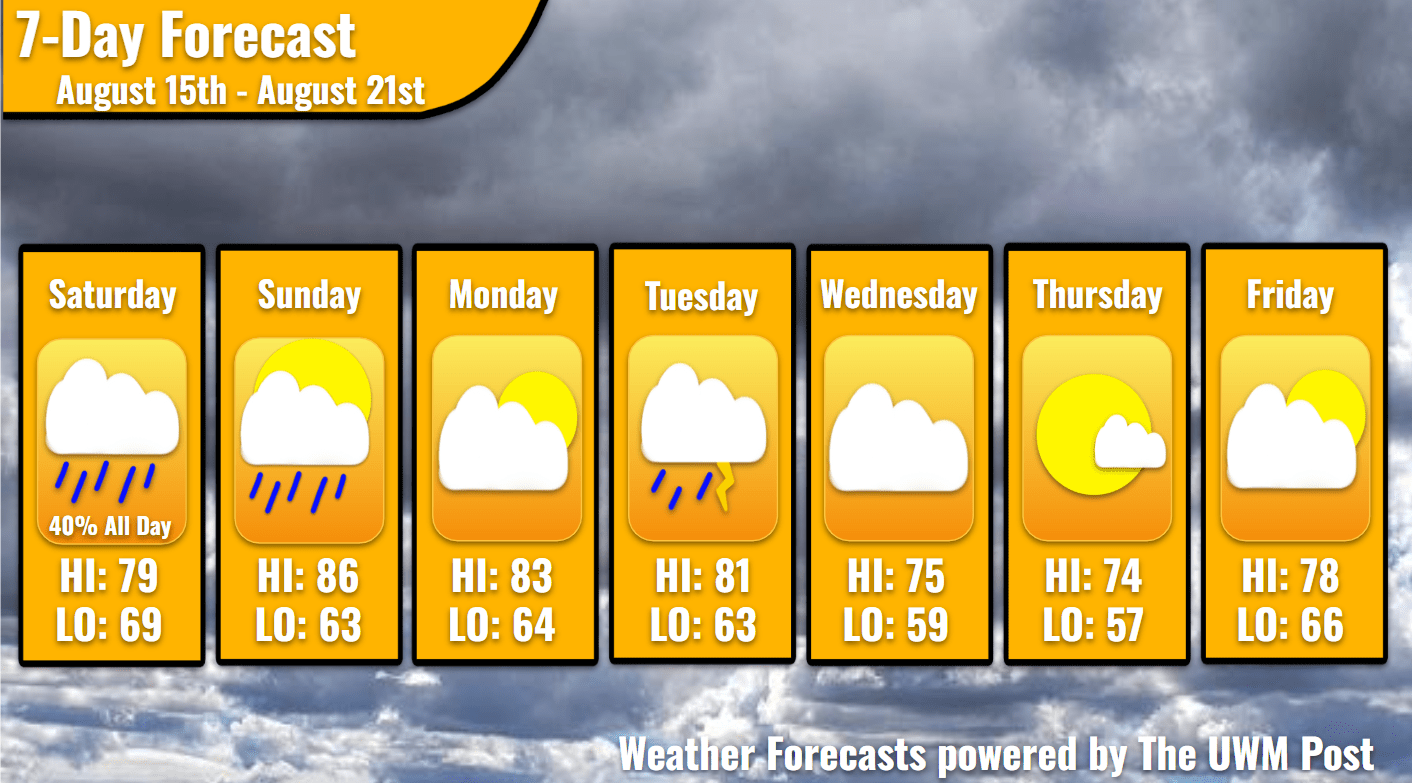
Overview: The Weekend Weather Report August 15th shows a humid weekend until a low-pressure system clears, only to revamp for Tuesday’s storms. Thankfully, temperatures cool down mid-week but rise on Friday.
What is this? This report looks at the weather over the next seven days. The forecaster offers a bit more detailed information about the weekend and more insight into what is happening with our weather.
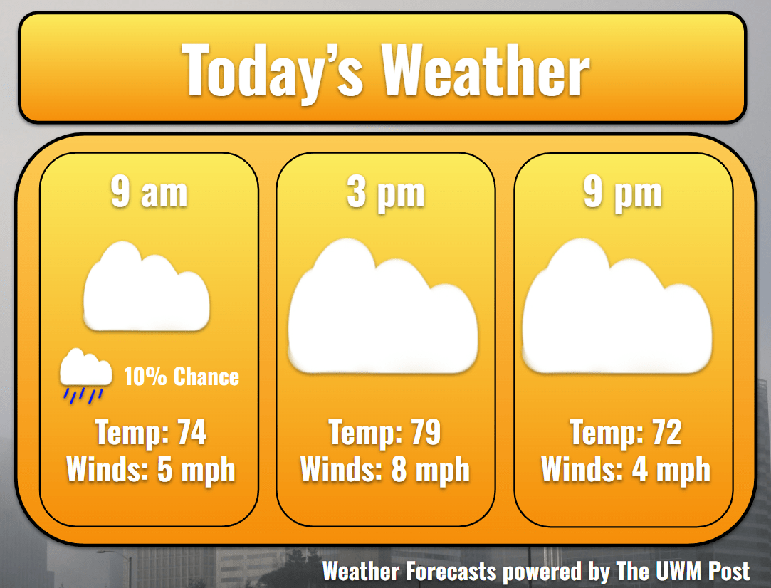
Today: With a low-pressure system entering early this morning to clear out by tomorrow afternoon, Milwaukee’s rain chances increase. From 8-11 a.m., south of I-94 and east of I-794 maintain a 20% chance of showers, while the north only has a 10% chance. These percentages not only represent the chance but also the area coverage. This morning, the raindrops might avoid certain neighborhoods, and drip on others. Otherwise, temperatures start near 74 mid-morning, rise to 79 in the afternoon, and start falling after 5 p.m. During the evening, heavier rain showers develop along I-43 and I-94 near Elkhorn and Oconomowoc, respectively. Traveling east, they arrive in Milwaukee by 6 p.m. and dissipate by 8 p.m. Along their journey, they might break up enough to avoid Milwaukee, so west of Waukesha has a 60% chance of showers versus Milwaukee’s 20%. Winds average 7 mph for most of the day.
Tonight: Thanks to the spotty rain, dewpoints should fall out of the 70s temporarily. As temperatures ease to 69 for a low, clouds persist. Winds turn from the southeast to the southwest in anticipation of the incoming frontal boundary. The low-pressure system sends through another round of showers on this, which arrives by 5 a.m. and continues until 7 a.m. Sunday. The system’s energy could produce the odd rumble of thunder and short-lived downpour, so stay aware if traveling during these hours.
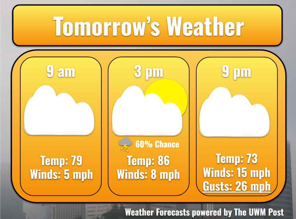
Tomorrow: The morning front does nothing for Milwaukee’s temperatures. We climb through the 70s in the early morning and hit a high of 86 in the afternoon. This is coupled with dewpoints of 73, so be sure to hydrate and limit outdoor activity in the midday. Clouds remain overhead despite a strengthening northwestern wind of 10 mph with gusts up to 15 mph. Around 5 p.m., Southeastern Wisconsin might receive one more line of showers before the low pressure releases its grip on the region. Expect a brief, but substantial rainfall with an occasional boom of thunder. Gusts behind the storms rise to 30 mph on winds of 15 mph due to cold air rushing into the area.
Tomorrow Night: Winds turn to come from the north, blasting Milwaukee’s temperatures down into the 60s. We bottom out at 63 degrees with comfortable dewpoints. Clouds finally start to break up before the dawn of another work week. A high-pressure system begins making its way into the Midwest and down into the Ohio River Valley. This sustains the winds out of the north for at least another day.
Monday: Driving to work should prove easy, if traffic keeps to a minimum, but be wary of northern wind gusts of 20 mph. Without many clouds above, Milwaukee heats back up to 83 for a high. Winds cool us down in the night, though, sending temperatures back to 64 degrees. Sadly, northern winds shift to the west and calm, keeping things a bit warmer than Sunday. This is due to the high-pressure system making its exit over Ohio and out east. A low-pressure system from the arctic will have dropped down into Canada by now, strengthening as it connects with the past low. This whole system comes back through once more on Tuesday.
Tuesday: Potentially heavy thunderstorms are brewing. Before they enter, southern winds aid in heating us up for the day. As the low pressure rotates in from the northwest, a line of showers dumps some rain on Eastern Wisconsin in the morning. This line was formed from dying storm cells from the night before in Minnesota, so if the timing changes for their storms, ours will, too. Stay up to date with your forecasts this week on Monday. Winds then hail from the west at 10 mph with gusts of 24 mph. We heat up to a high of 81, oppressed by humidity brought up by Monday’s southwestern winds. This sets up a prime environment for late-day storms, especially with the cold front’s boundary arriving around 7 p.m. Expect some downpours, gusty winds up to 35 mph, and the extremely isolated chance of hail. We cool to 63 overnight.
Wednesday: Clouds hang around after the low exits to the east, but not for long. As winds now come howling out of the northeast, winds average 12 mph with possible gusts of 30 mph. This aids in driving the clouds away and cooling us down. Temperatures reach a lovely 75 for a high and drop to 59 for a low. Eventually, winds calm down, as the low-pressure system’s influence ends.
Thursday: High pressure comes back again, though some puffball clouds still frequent our sky. With winds of 6 mph and dropping, we feel like Wisconsin again at 74 degrees for a high and 59 degrees for a low.
Friday: Our high pressure decides to move away to the southeast, so Milwaukee experiences increasingly cloudy skies. Southeastern winds average 5 mph, and gusts stay below 20 mph. Temperatures increase substantially, placing the high in the upper 70s and low in the lower 60s. Friday night might find some rain waiting for us, so as always, stay tuned for more weather updates!