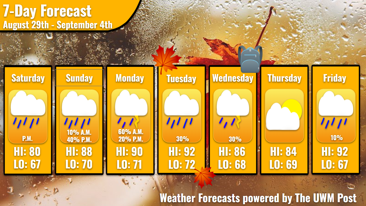
Overview: Milwaukee’s Weekend Weather Report August 29th, 2026, previews a tropical start to fall, with on-and-off rain chances, temperatures hovering near 90, and dewpoints in the upper 60s.
What is this?: This report looks at the weather over the next seven days. The forecaster offers a bit more detailed information about the weekend and more insight into what is happening with our weather.
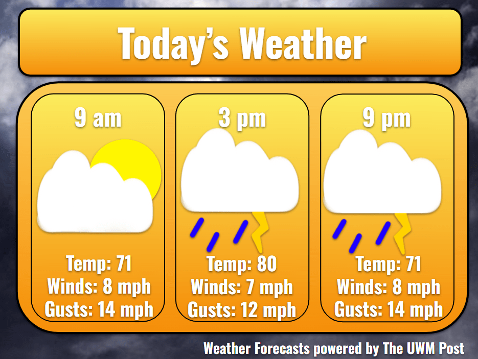
Today: Pleasant temperatures contrast the increasing clouds Saturday morning, as Milwaukee sits at 71 by 9 a.m. Decaying from last night, a storm system approaches Milwaukee from the northwest, sending out a chance for drizzles around 10 a.m. This may blow over, so I would not be concerned about the morning for any outdoor activities. However, the afternoon witnesses the revival of the thunderstorms, especially from 4-10 p.m. Despite the large timeframe, the storms only dapple the Milwaukee area instead of fully covering it. This leads to quickly passing individual showers and a total rainfall of a tenth of an inch. Due to the clouds and 8-mph winds from the south, temperatures fight to surpass 80 degrees by 3 p.m., but to no avail, falling to 71 by nightfall. Gusts for the day should stay below 18 mph.
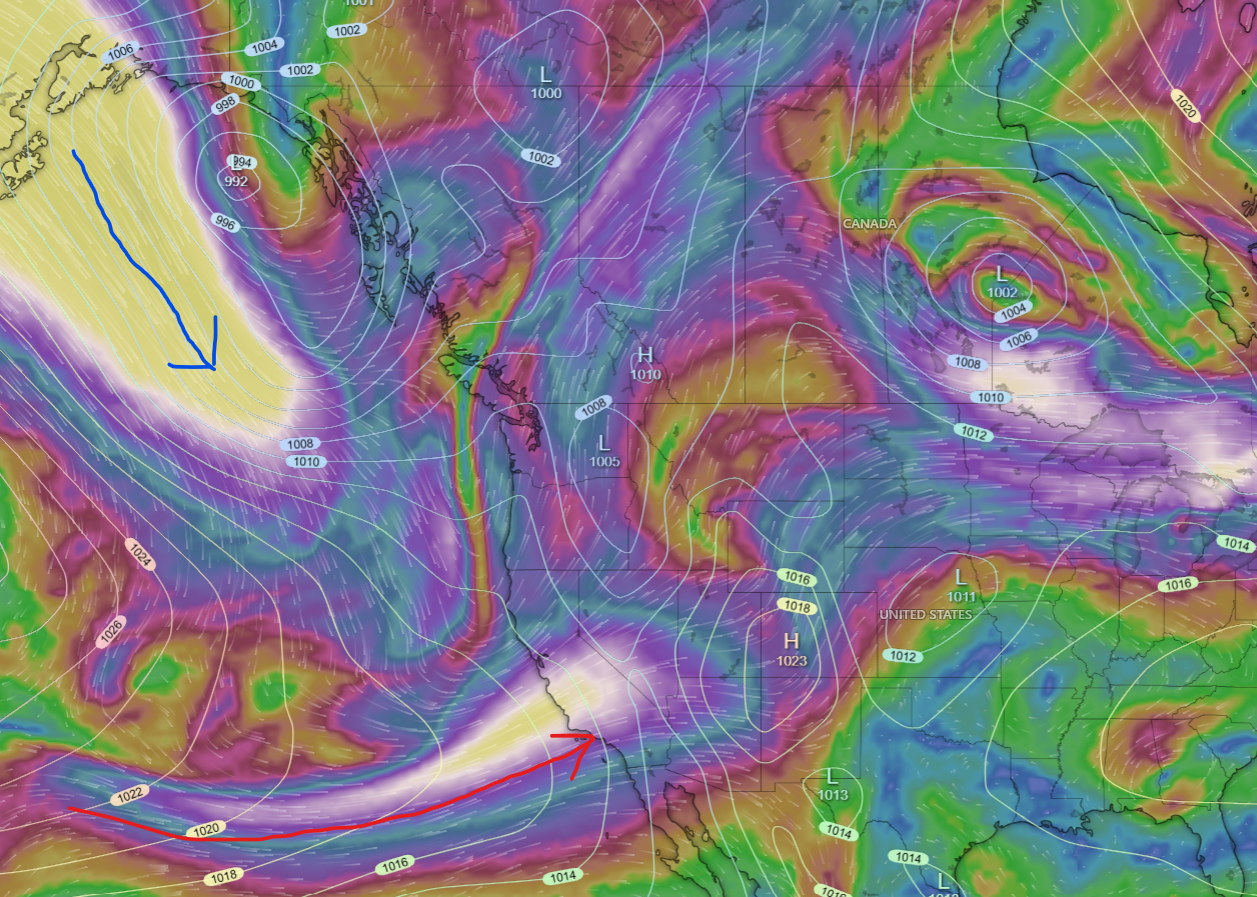
Tonight: Milwaukee stays clear from rain until tomorrow morning. Temperatures stick in the upper 60s with dewpoints in the mid-60s, as winds from the southwest continue at 10 mph. Over this week, the subtropical jet stream holds a course roughly from Los Angeles to Milwaukee. This holds a weather pattern in place until a polar jet stream ‘gust’ knocks it out of its place. A low pressure will sit over in the northwestern Great Plains until prompted westward. Then, it will strengthen and travel toward the northern tip of Lake Superior. While this happens, Milwaukee feels the warmer, humid air being forced northward. After the warm front, the low moves toward the west a bit more and softens its cold front when it arrives in Milwaukee. A high pressure attempts to form in its wake, but this fails. The process then repeats.
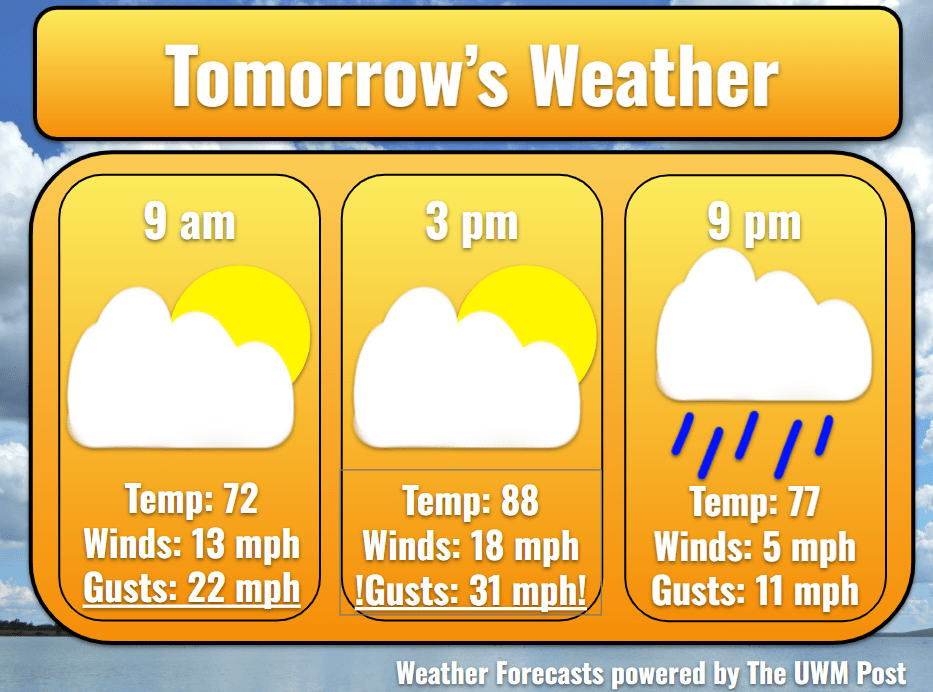
Tomorrow: Around 5 a.m., some showers form south of I-94 and could dampen our Sunday morning, but these should stay south. As the resident low-pressure system in the Great Plains moves and deepens, winds increase from the southwest. Averaging 14 mph, gusts easily jump up to 30 mph, so take extra care in driving on Sunday. Temperatures reflect the southern influence and launch up to 88. Dewpoints inch upwards as well, near 67. As clouds continue overhead, more rain pops up in Central Wisconsin around noon. This should dissipate before arriving in Milwaukee. But behind these, a few more showers and possible thunderstorms grow. These enter the downtown area by 5 p.m. and exit by 9 p.m.
Tomorrow Night: Winds calm temporarily overnight to 8 mph. Despite a bit of rain, dewpoints remain in the mid-60s for the night. Broken clouds still pass overhead, as temperatures struggle to drop below 70. With the low pressure now to our northwest, the low begins to ease and break off from its southern counterpart. The northern low travels westward into Monday, becoming a main driver for Monday’s storms. The southern low backs into the Rockies and holds steady until the upcoming weekend.
Monday: Storms form in the morning of Monday due to overnight instability and the low pressure’s warm front. Models currently time this out to arrive by 6 a.m. Hazards associated with this storm could be small hailstones, wind gusts up to 40 mph, and low visibility due to heavy rainfall. Accumulations vary, but Milwaukee sees around a quarter inch of rain from this. We will be keeping a close eye on these storms, so stay tuned! Afterward, winds remain higher, averaging 10 mph with gusts up to 22 mph. Temperatures rocket back up to 90 degrees with dewpoints in the 70s. With the sun shining on the dampened earth and help from another small storm system, moisture returns into the air and could induce some showers later in the day. Overnight, temperatures only sink to 71.
Tuesday: Once again, due to overnight instability from the passing low pressure and warm temperatures, Tuesday morning might hold more storms. Beginning around 3 a.m., precipitation chances spike until noon. Within this time period, thunderstorms and showers move through, especially north of Milwaukee. Winds calm to 8 mph for the first day of meteorological fall, though still gusting up to 20 mph. Empowered by the low’s warm front the night before, temperatures enter the low-90s for a high at 92. Dewpoints stick around 70 again, so remember to limit time outside and drink lots of water. Daytime heating likely causes some showers in the late evening and early night. Following this, winds calm and temperatures sink to the dewpoint of 72.
Wednesday: For the first day of school at UW-Milwaukee, students can expect a hot day hopefully saved by a lake breeze. We launch up to 86 for a high with dewpoints sinking. Thanks to the northern low pressure tossing the wind back across the lake towards Milwaukee, we enjoy a steady cool breeze in the afternoon and evening. Temperatures cool slightly, nearing the 70s before officially returning below 70 degrees to the low of 68.
Thursday: Temperatures ease more as the northern low pressure exits toward the Atlantic Ocean, only reaching 84 for a high. Dewpoints stay in the mid-60s also. Though a few storms pass to our north and south, we should not see much more than a tenth of an inch of rainfall. We drop to 69 degrees in the night with a strengthening southern wind of 8 mph. Gusts reach 20 mph.
Friday: Before Labor Day Weekend, temperatures regain their footing and hit 92 for a high with dewpoints in the upper 60s. Winds increase to 10 mph from the southwest as the low pressure over the Rockies strengthens. As we watch the clouds grow above, precipitation chances increase in the evening. In the night, temperatures drop to 67. Stay tuned for Monday’s forecast!