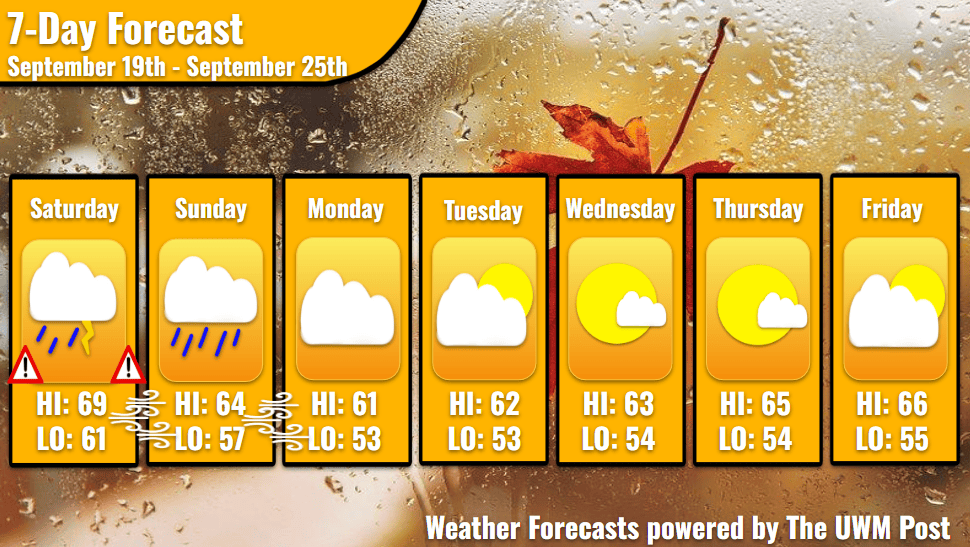
Overview: Milwaukee’s Weekend Weather Report September 19th, 2026, starts with excessive rain and higher winds, but calmer weather follows. Temperatures mostly remain in the 60s for highs and 50s for lows.
What is this?: This report looks at the weather over the next seven days. The forecaster offers a bit more detailed information about the weekend and more insight into what is happening with our weather.

Today: Make sure that sump pump is running, for the morning of Saturday holds some possible flooding for Southeastern Wisconsin. Remember, when spotting a flooded roadway, “Turn around, don’t drown.” Due to winds aloft pushing and lifting the extremely saturated atmosphere we have, heavy rainfall dominates the morning. Think of this like a wet cloth being wrung out and the winds are the mechanism twisting the cloth. With so much water being wrung out, the precipitation bumps into each other a bunch, inducing thunders. These exit around 7 a.m. but the rain lingers until 10 a.m. at least. Temperatures spring up from 63 to 69 by the afternoon. Between 11 a.m. and 5 p.m., Milwaukee might be free of substantial rain, and winds start calming into the single digits by evening. Gusts, beginning the day at almost 30 mph, drop to 10 mph by nightfall.
Tonight: Another round of storms enters Milwaukee from the northwest at 5 p.m. with more heavy rain and lightning. The now exiting low pressure swings through another system of storms using the same mechanism from the morning storms. Despite less twist, the storms contain respectable energy due to the sun’s heating. Rainfall amounts during the night look tamer than the morning, yet totals still surpass an inch. Over the full day, midnight to midnight, Milwaukee likely receives 3 inches of rain. As always, be careful on roadways, especially getting into the morning of tomorrow. Winds from the north invade Southeastern Wisconsin to the tune of 20 mph, gusting up to 40 mph. Temperatures don’t get too far with the wind off the lake, but drop to 61 in the night.
Tomorrow: We begin in a slight fog with clusters of rain clouds still exiting to the southeast. These overshadow the day, as temperatures struggle to exit the low-60s. Winds increase to 25 mph with gusts of 40 mph over the day. With such high winds out of the north and temperatures consistently within the 60s in the Lake Michigan area, we only hit a high of 64. As a high-pressure system sinks in from the northwest, the difference of pressure across the state increases. This keeps our winds high into the night.
Tomorrow Night: Temperatures cool into the high-50s as clouds slightly decrease. Higher pressures dominate from here out. Some features of this high pressure might cause some brief showers later in the week, but chances are low.
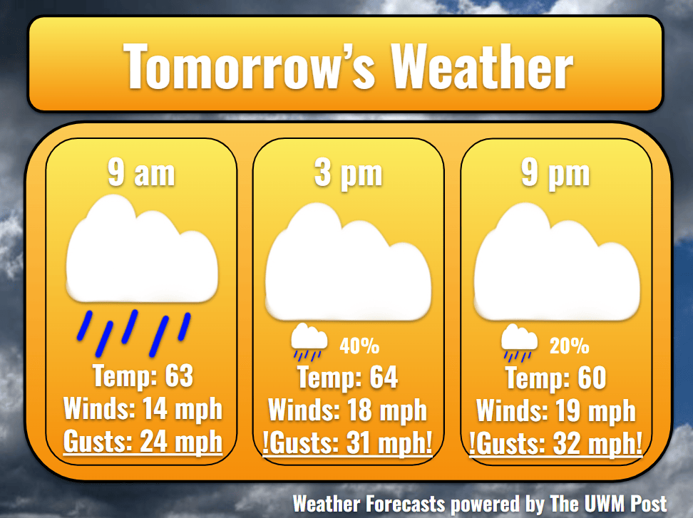
Monday: While the high-pressure difference exits the area, the high-pressure system gets closer. Winds still average 12 mph over the day with gusts up to 35 mph. Fighting against more cloud cover, temperatures only hit 61 for a high. With another low pressure near us, some clouds stick in the sky. These dissipate into the night though, allowing temperatures to drop to 53. Winds decrease to 14 mph.
Work Week: Tuesday’s temperatures only regain one degree for a high of 62 and low of 53. Averaging 11 mph, winds finally become bearable again, gusting only to 25 mph. Clouds increase a bit over the day, but leave with the coming of Wednesday morning. On Wednesday, temperatures hit a mild 63 with a low of 54. Inconsistent wisps of clouds ride the winds of 8 mph into a calmer Thursday. Rising a bit more, temperatures get up to 65 for a high and 54 for a low. Winds back off a bit more, as gusts stay below 20 mph for most of the day. As clouds increase slightly into the night, Friday looks to be a bit cloudier. Temperatures reach 66 with a low of 55 in the night. Some rain might be entering for the upcoming weekend so stay tuned!