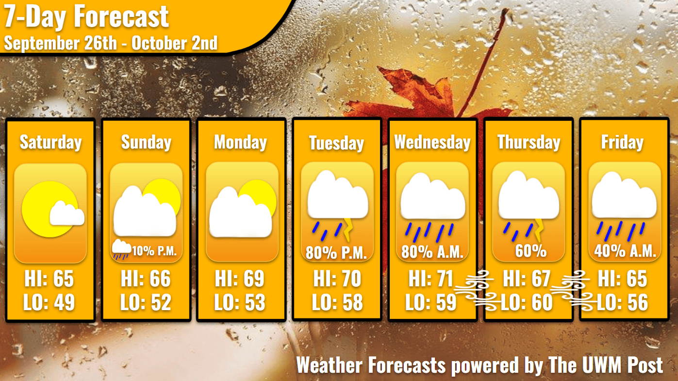
Overview: Milwaukee’s Weekend Weather Report September 26th, 2026, relaxes in the mid-60s over the weekend, returns to the 70s briefly, and then plunges back into precipitation on Tuesday.
What is this?: This report looks at the weather over the next seven days. The forecaster offers a bit more detailed information about the weekend and more insight into what is happening with our weather.
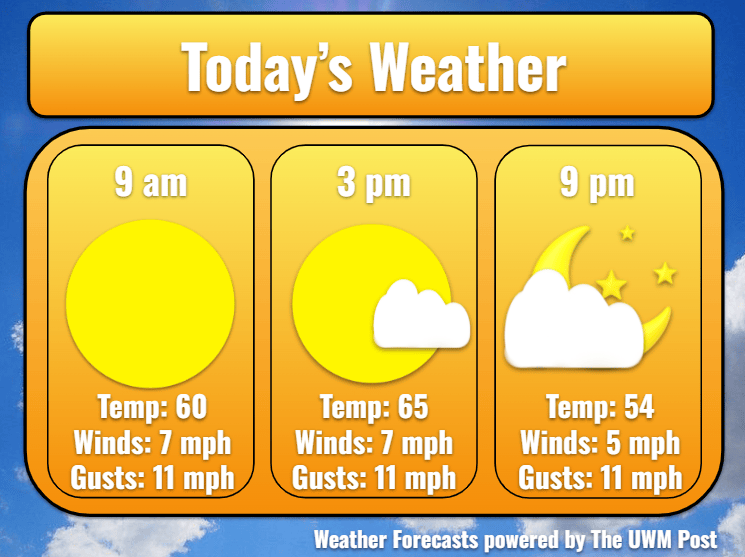
Today: As the East Coast deals with their Nor’easter, upper-level winds helping drive it cause our skies to be free of clouds for most of the day. Starting out at 60 degrees at 9 a.m., our temperatures rise to 65 by the mid-afternoon. Near the lake, temperatures maintain a fall-like chill thanks to a 5-mph wind coming from the lake’s direction. Lake Michigan currently sits at a temperature of 59. Thus, any winds blowing over the lake during the day today would on average be chillier than over land. Clouds increase into the evening, as a low-pressure system to the west attempts to create a rainy Sunday for Milwaukee.
Tonight: More often than not, partly cloudy skies overshadow tonight’s full moon, often called the Leaves-Turning or Harvest Moon. Winds fall to a breeze with temperatures also falling, straight past the mid-50s into the 40s. Overnight temperatures sink to a whooping 49-degree low. Going a bit further inland, one could even see low-40s. The low-pressure system dissipates noticeably overnight but forges onward toward Milwaukee as Sunday morning breaks.
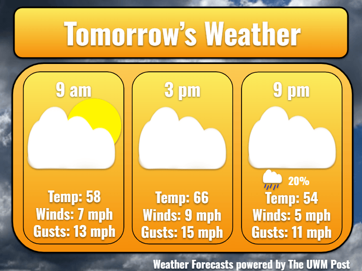
Tomorrow: High pressure over the Great Lakes holds strong for another day. Temperatures rise to 66 for a high before quickly retreating into the 50s in the evening. Clouds penetrate through from the west, only bringing a chance drizzle from 5-10 p.m. Winds pick up slightly from yesterday, averaging 6 mph with gusts up to 20 mph. Blowing in from the north, these relatively dry winds help decrease precipitation chances. However, this does not mean dewpoints remain low, because the moisture still diffuses into the area. This extra moisture becomes a driving factor of Tuesday’s weather.
Tomorrow Night: Precipitation chances end at 10 p.m., so dropping temperatures attempt to relish in the decreasing clouds. We reach a low of 52. Continuing from the north, winds drive in the last cold air Milwaukee sees for a little while.
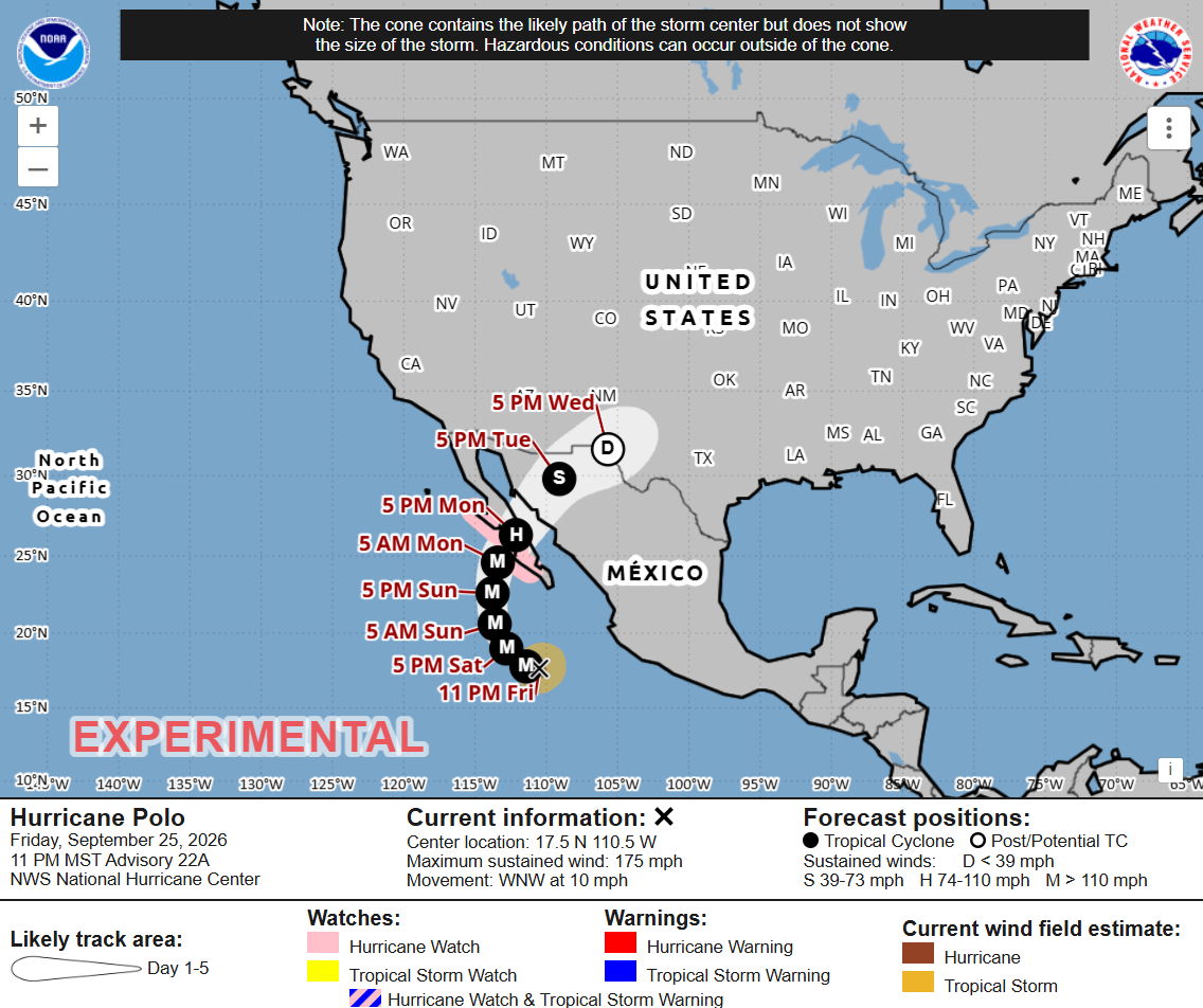
Monday: As a beautiful fall sunrise graces the city to begin the work week, eastern winds breeze about at 6 mph. Temperatures climb higher into the 60s, topping out at 69 in the sunny afternoon. Monday proves to be a crucial day for Milwaukee’s weather. Firstly, Hurricane Polo is forecasted to make landfall in Baja California by 7 p.m. Monday. Due to the storm’s aggressive nature so far, upper-level winds from this system likely influence our midweek. Secondly, with the Nor’easter out of its way, our high pressure gets shoved eastward by a strong upper-level jet stream pushing from the southwest. Upon this jet, moist air enters the Great Lakes. Winds increase slightly to 8 mph in the night, but gusts stay below 15 mph. Bottoming out at 53, temperatures are supported from southeastern winds and increasing clouds.
Tuesday: Gathering strength, a low pressure swings over Duluth and out over the Upper Peninsula. This motion causes winds to strengthen from the southwest, averaging 10 mph with gust of 20 mph. Consequently, temperatures climb into the low-70s. Additionally, the low induces some significant precipitation. From Tuesday around 5 p.m. until Wednesday around 10 a.m., Milwaukee likely receives three-quarters of an inch of rain. This arrives mainly within long bands of heavy rainfall or embedded thunderstorms during Tuesday. Due to the rain, temperatures easily make it back to 58 and hold steady in the night.
Note: Due to the modeled variability in Hurricane Polo’s track and likelihood of its transition into a mid-latitude storm system, forecasting beyond Wednesday becomes difficult. Upper-level winds likely support this “extratropical transition,” but where the system trends from here remains uncertain. Using the knowledge available, I offer a rough prediction for Wednesday, Thursday, and Friday.
Extended: On Wednesday, temperatures continue to rise, peaking at 71 with a low of 59. Tuesday’s precipitation exits in the morning, but winds strengthen even more from the southwest, gusting up to 25 mph. If successfully transitioned and deepening accordingly, the remnants of Hurricane Polo enter in the early morning of Thursday. Heavy rain and thunderstorms are possible with wind gusts of 35 mph or more. This lightens up after we hit our high of 67 in the afternoon. After Thursday’s low of 60 degrees, Friday bounces back to 65 for a high. Temperatures struggle against a strengthening northeastern wind with 30 mph gusts, resulting in a low of 56 degrees. High pressure influence from the north hopefully keeps Friday drier than Thursday. Keep an eye out for updates, though!