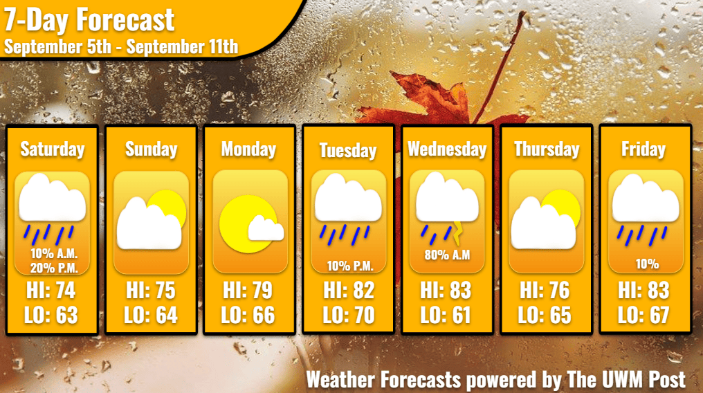
Overview: Milwaukee’s Weekend Weather Report September 5th, 2026, relaxes in the mid-70s temperatures until Labor Day Monday tips the scales into the 80s. Two storm systems flare up the following week.
What is this?: This report looks at the weather over the next seven days. The forecaster offers a bit more detailed information about the weekend and more insight into what is happening with our weather.
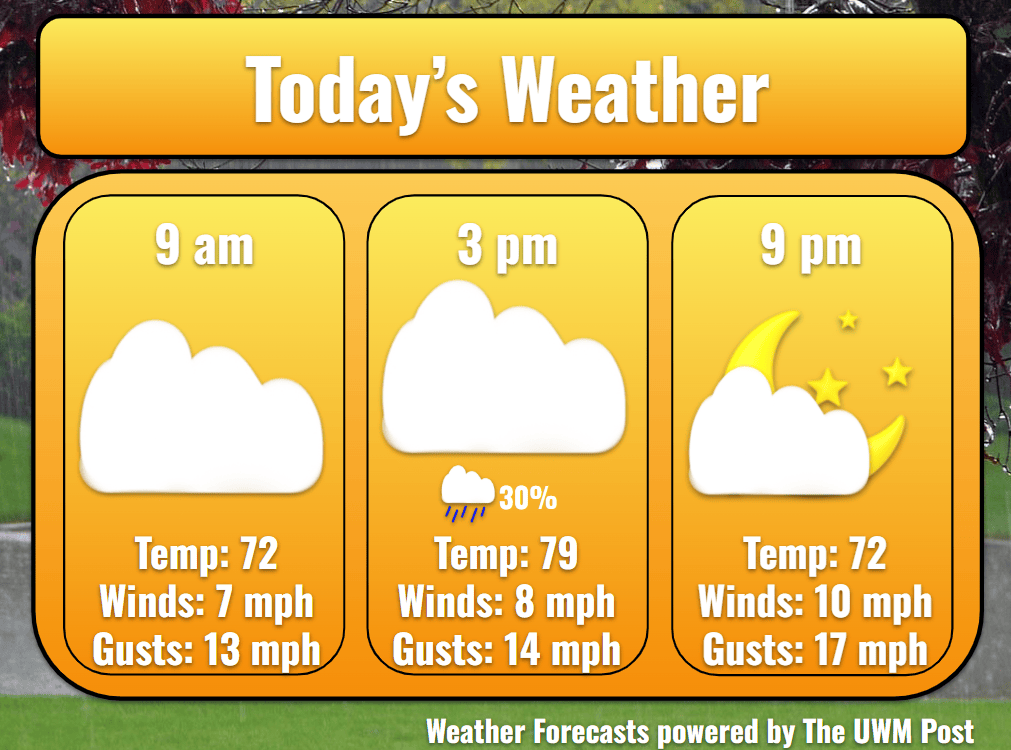
Today: Fog covers the sunrise of Saturday in a greyscale blanket. Waking up a bit later on the weekend, one finds overcast skies and low-70s temperatures at 9 a.m. Today’s winds hold relatively steady out of the northeast at 8 mph with gusts up to 17 mph. This aids in holding our temperatures around 74 for a high at 10 a.m., just as the fog has lifted. Precipitation chances spike midday, as the entering high-pressure system pushes out the rest of Friday’s storms. From 10 a.m. until 4 p.m., Milwaukee might dampen due to scattered drizzles, especially around 1 p.m. Total rainfall should top out at less than a tenth of an inch. Otherwise, temperatures cool slightly to 70 in the afternoon, and continue cooling after 7 p.m.
Tonight: Clouds clear up for a gorgeous night at 63 degrees. Winds calm and dew points also drop to the low-60s. A light fog covers the metro from 10 p.m. until 9 a.m. on Sunday.
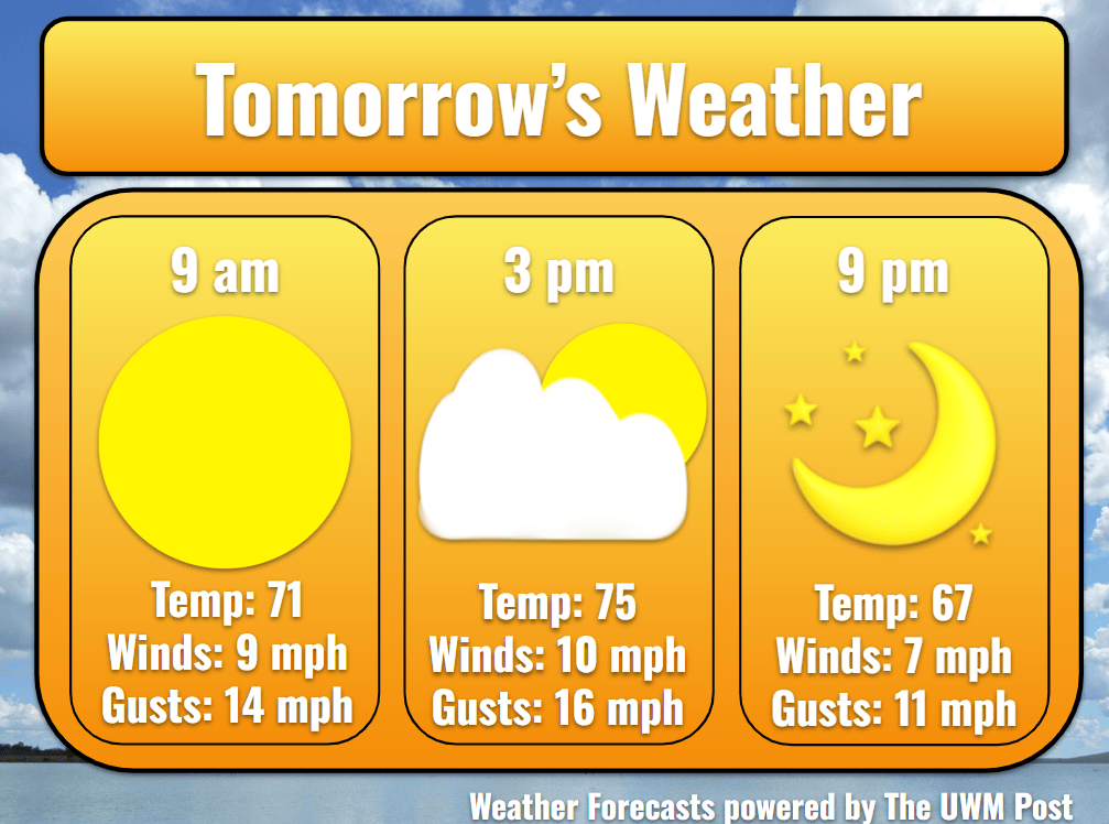
Tomorrow: Milwaukee witnesses another temperate day with calmer wind, mid-70s temperatures, and blue skies. Coming almost directly off the lake, winds seldom rise above 12 mph with occasional 18-mph gusts. Temperatures again stay below historical averages of 77 degrees with a high of 75. Afternoon warmth cools into the evening to 67 by 9 p.m.
Tomorrow Night: Turning to come from the southeast, winds flow through Milwaukee at 6 mph. Despite the change, temperatures still make it down to 64 for a low. As our high pressure over Michigan softens, another high pressure from the north merges. This bodes well for Monday’s weather due to the high-pressure system buffering any rain systems attempting to precipitate over Southeastern Wisconsin.
Monday: Temperatures slip back into the upper 70s due to increasing winds. Averaging 10 mph with gusts of 18 mph, winds shove in from the southeast with a familiar warmth. Dew points float up into the mid-60s, as our temperatures top out at 79. Gusts of wind remain around 18 mph. Filling more of the sky, clouds grow much larger than previous days. As a low-pressure system near North Dakota deepens, the sinking surface pressure to our northwest draws on winds from our direction. The greater the pressure difference, the greater the winds. This happens much more noticeably on Tuesday and Friday this week. Resulting from this warm southeastern wind, our nightly low only reaches 66.
Tuesday: While the low pressure moves eastward, pressures drop faster, increasing winds to 14 mph from the south. Gusts might reach up to 30 mph. Take extra care driving, especially on roads running east-west such as I-94 between interchanges. Temperatures reflect this by jumping into the 80s. Our high hits 82, before clouds begin filling in the gaps of the sky. Going into the night, some pop-up rain is possible, but significant chances start around midnight. Meanwhile, temperatures bottom out at 70 degrees.
Wednesday: From midnight until noon, Milwaukee gets up to a half inch of rain. This differs over the area just like last Thursday’s flooding, so some areas might receive less than others. Flashes of lightning are likely within this period as well. Currently, this does not look severe, but keep an eye out for any updates. Although coming out of the storms around noon, temperatures manage to return to the 80s for a high of 83. Winds of 12 mph and gusts of 30 mph commonly breeze through downtown during the day. With the low-pressure system now exiting to our northeast, nighttime winds with their gusts calm to 8 mph. Cooler temperatures enter upon these winds, dropping the low to 61. Some fog likely forms in the night.
Thursday: As a weak high-pressure system attempts to replace the exited low, fair weather returns to Milwaukee for a day. Temperatures only rise to around 76 for a high under mostly sunny skies. A substantial breeze off the lake means cooler weather but also gusts up to 24 mph despite winds averaging 6 mph. After trying to strengthen, the high pressure slowly travels east. Winds may be out of the east for the majority of the day, but they turn south overnight due to the high pressure’s motion, barring the temperatures from dipping any further than 65. Southern winds could come back with a vengeance.
Friday: As another low pressure over the Northern Plains sets up to enter the Midwest, southern winds toss temperatures into the 80s again. Gusting up to 26 mph, the evening commute is expected to be worse than the morning due to winds. Clouds congregate into the evening and night. In anticipation of the low pressure’s passing, temperatures remain elevated at 67 for the night. Precipitation enters in the night, so stay updated with your weather right here to hear more about it!