

Overview: Milwaukee’s Weekend Weather Report August 22nd, 2026, finds a shower Saturday evening before a gorgeous Sunday. We then build into midweek storms, cool, then build into next weekend showers.
What is this?: This report looks at the weather over the next seven days. The forecaster offers a bit more detailed information about the weekend and more insight into what is happening with our weather.
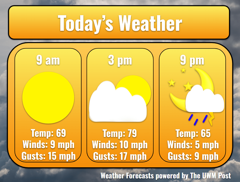
Today: Despite a beautiful sunrise in the mid-60s with light winds, we find some lingering clouds which form into showers in the late day. Temperatures enter the 70s after 10 a.m. to top out at 79 by 3 p.m. Dewpoints stay close to 60, slightly stickier than some might like. As Friday’s low pressure strengthens over Eastern Michigan, northwestern winds increase to 10 mph, gusting up to 20 mph. This all comes with cloudier skies in the afternoon and into the evening. Precipitation chances start at 5 p.m. and continue until 10 p.m., as both sufficient moisture in the air and instability from daytime heating allow for storms to form in the evening. These then dissipate after nightfall.
Tonight: The storm chances peak from 6-8 p.m. Due to the semi-organized group of showers which could be produced, the whole Milwaukee area should see around a tenth of an inch of rain. Winds are expected to be a maximum of 35 mph within the strongest portions of the storm. This also comes along with localized heavy rain chances of 5% and a stray thunder or two. Otherwise, our night clears up into Sunday morning. The pulling back of the clouds and the northwestern winds send Milwaukee’s temperatures down to 56 degrees for the night.
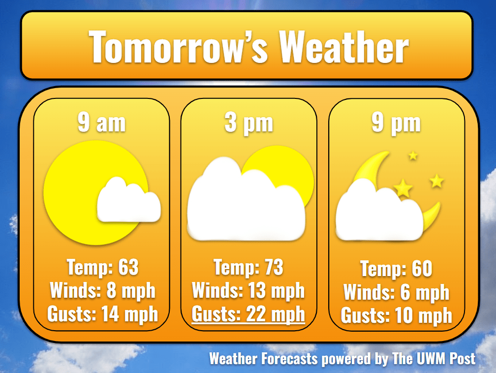
Tomorrow: With the low pressure exiting toward Maine, a high pressure squeezes its way down into the Midwest. Clouds keep some presence in our skies after taking a break in the morning. Temperatures climb to 63 by 9 a.m. and hit 73 before going back down to 60 by 9 p.m. Aiding in keeping us cool, northern winds of 12 mph with gusts up to 24 mph only calm once we get to the evening. Only a few puffball clouds float across the sky during the day.
Tomorrow Night: While the winds slow to an acceptable 6 mph with 10 mph gusts from the northeast, temperatures drop into the 50s. Temperatures below 57 have not made an appearance in Milwaukee since June. According to National Weather Service data sourced from here, August regularly witnesses a decrease in temperatures going into September. Milwaukee might bottom out at 54 degrees for a low however, a 10-degree discount from the climate normal. This is a much-appreciated break after such a hot summer.
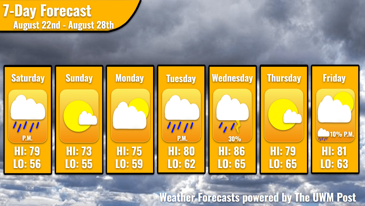
Monday: Starting the work week off on the right foot, a partly cloudy sunrise greets commuters. Winds lighten up and temperatures increase noticeably from Sunday to 75. As our high pressure weakens and leaves to the southeast, a storm system to our west induces some clouds. This most likely affects not only the day but also sunset viewing. Thankfully though, precipitation holds out for another day. Temperatures drop to 59 in the night as clouds move out once more.
Tuesday: On the second day of the work week, the weather ramps back up. Winds from the south force moisture and clouds back into our forecast. Returning to the 80-degree territory, our dewpoints remain near 60. Over the course of the day, a low pressure moves into Wisconsin, potentially sparking a few showers out west. These die down, but still arrive for us in the form of rain chances around 10% from 8-10 p.m. After this, temperatures fall to 62 degrees.
Wednesday: Dewpoints spike to a sticky 68 maintained by southwestern winds, and temperatures enter the upper 80s. While the low pressure continues its Midwestern tour, it develops further, creating more well-defined cold fronts which sweep through Milwaukee. These could form drizzles in the morning and induce a thunderstorm chance of 30% for the afternoon and evening. The timing and the intensity of these remain a mystery, but one might expect higher winds of 40 mph, lightning, and heavy rain to be possible. Winds of 12 mph out of the northwest help in cooling us down to 65, just about the dewpoint. One can then expect fog on Thursday morning.
Thursday: A brief and weak high-pressure system enters and exits over the next two days. Despite its size, we still experience no rain and a 79-degree Thursday. Clouds only occasion the sky in the late afternoon into the evening. Winds stay calm also at a 5-mph speed with 10 mph gusts. Overnight, temperatures fall back to the dewpoint around 60 degrees, so expect a bit of fog on Friday morning.
Friday: With another system on its way, winds breeze about more, averaging 6 mph with gusts up to 30 mph. Clouds stay away for the first half of the day, only to return later ahead of a newly developing low pressure. Temperatures hit 81 for a high and 63 for a low. Rain possibilities increase into the night, so stay tuned for more weather updates!
Great weather report and so well worded!