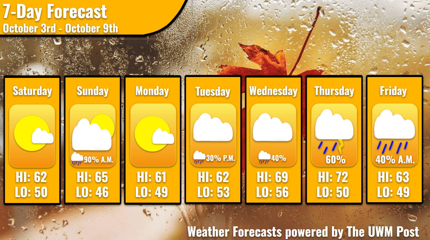
Overview: Milwaukee’s Weekend Weather Report witnesses a sudden warm-up midweek, possibly reaching the 70s, and then showers following with a blast of cooler air.
What is this?: This report looks at the weather over the next seven days. The forecaster offers a bit more detailed information about the weekend and more insight into what is happening with our weather.
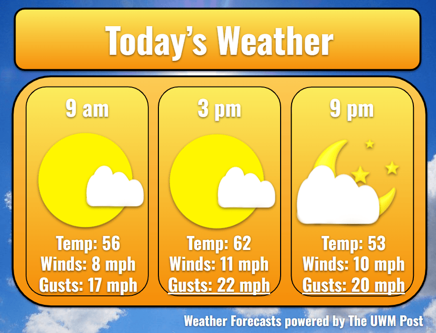
Today: As our fair-weather high pressure exits to the east, clouds increase slowly, adding some contrast to our Saturday sunrise. Winds pick up out of the southeast and turn to the south by the end of the day. Averaging six mph, the winds start calm but get up to 12 mph in the afternoon. Though winds calm somewhat in the evening and night, gusts keep above 20 mph. Temperatures try to reflect this warming trend, but they stay near 62 by the lake. With a small low-pressure system starting to enter Southeastern Wisconsin by the evening, chances of precipitation increase along with the clouds.
Tonight: Around midnight, the first drizzles begin over Milwaukee. Temperatures fall faster around this time due to the system’s cold front sweeping through, but only slightly faster. After wetting the pavement, the rain quickly leaves to the southeast at 4 a.m. Behind the rain, wind gusts could hit 25 mph. Temperatures drop further to touch 50 before Sunday’s sunrise.
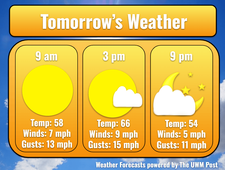
Tomorrow: Despite the high clouds’ absence, fog remains in the area until the late morning. Exercise caution when driving Sunday morning. Upon the clearing of the fog, temperatures attempt a jump to the high 60s. They only reach 65 degrees in Milwaukee as northwestern winds of 12 mph hinder this. Thankfully, the winds settle down in the evening, and gusts finally sink below 20 mph.
Tomorrow Night: A temporary high-pressure system sits above us overnight, shielding us from any precipitation. However, it does allow the temperatures to sink quite low. Near the lake, mid-40s dominate thanks to the lake’s warmth, but inland temps could reach 40 degrees. Clear skies dominate into the morning of Monday.
Monday: Still influenced by the high pressure, our work week starts wonderfully in the low 50s. Clear skies persist throughout the day with mostly calm winds and gusts barely reaching 18 mph. In the afternoon, temperatures hit the high of 61. After sunset, Milwaukee hits a low of 49 due to winds starting to increase out of the south.
Tuesday: Tuesday begins the increase of precipitation chances, though not before a beautiful sunrise. Temperatures increase to 62 as a low pressure in the north influences the Midwest. Southern winds of 12 mph shove in warmer air in the morning, but clouds fill in as our first chance of rain enters. More towards the end of day, the system could produce a few drizzles, but without pulling any of the Pacific’s or Gulf’s moisture, the rain produced shouldn’t be measurable. Now coming from the west, winds stay around 10 mph with gusts up to 20 mph. Temperatures only get down to 53.
Wednesday: After Tuesday’s drizzle, clouds remain overhead as the upper air water content holds steady. Temperatures launch up into the upper 60s with any southern winds produced on Wednesday. Averaging 8 mph, these breezes still can gust up to 22 mph. From the evening into the early morning of Thursday, the chances of precipitation spike again. With more favorable conditions, Eastern Wisconsin might see some more drips of rain but still amounting to very little. Overnight, we only get down to 56.
Thursday: With winds still varying from the west and south, temperatures break into the low-70s to peak at 72. Due to the positioning of the low-pressure system in the north, we likely have the majority of this forecast’s precipitation on Thursday. After building for the two days prior, clouds begin their thunderstorms out in the Northwoods and the Driftless areas before getting to Milwaukee by the evening. Accumulation by midnight amounts to a quarter inch or rain. Upon the end of this rainy cold front, temperatures sharply drop into the 50s. We bottom out at 50 in the night.
Friday: Possibly coming Friday morning, ultimately, the clouds should exit by the afternoon. Late day sunshine sends temperatures up to 63, but northern winds prohibit anything more. Gusts up to 20 mph are still possible. Temperatures dip back into the high-40s for a low. Rain might follow though, so stay tuned!