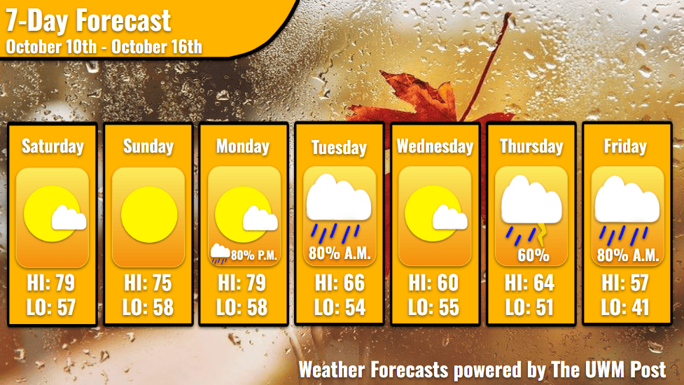
Overview: Milwaukee’s Weekend Weather Report starts like mid-summer, becomes drizzly and cooler on Tuesday, and after a larger system passes on Thursday, temperatures get frigid.
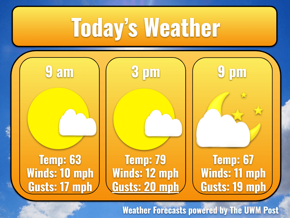
Today: After a cool sunrise, temperatures rocket up into the 70s. Southern winds of 12 mph encourage this jump, gusting up to 30 mph. As Hurricane Isaias (now only a tropical depression) dissipates outward, it stretches slightly north of the Appalachian Mountains. Its moisture aloft travels even farther and produces cloudy skies for us. Despite this, high clouds usually don’t block the sun well; in fact, they have a slight warming effect. Milwaukee’s temperature therefore flirts with 80 degrees before falling back into the 60s for a partly cloudy sunset.
Tonight: Escaping towards the clear skies, our day’s heat is lost quite quickly. Temperatures return to the 50s but stay around 57 with southern winds still present. Calmer now, winds average 10 mph with gusts up to 25 mph.
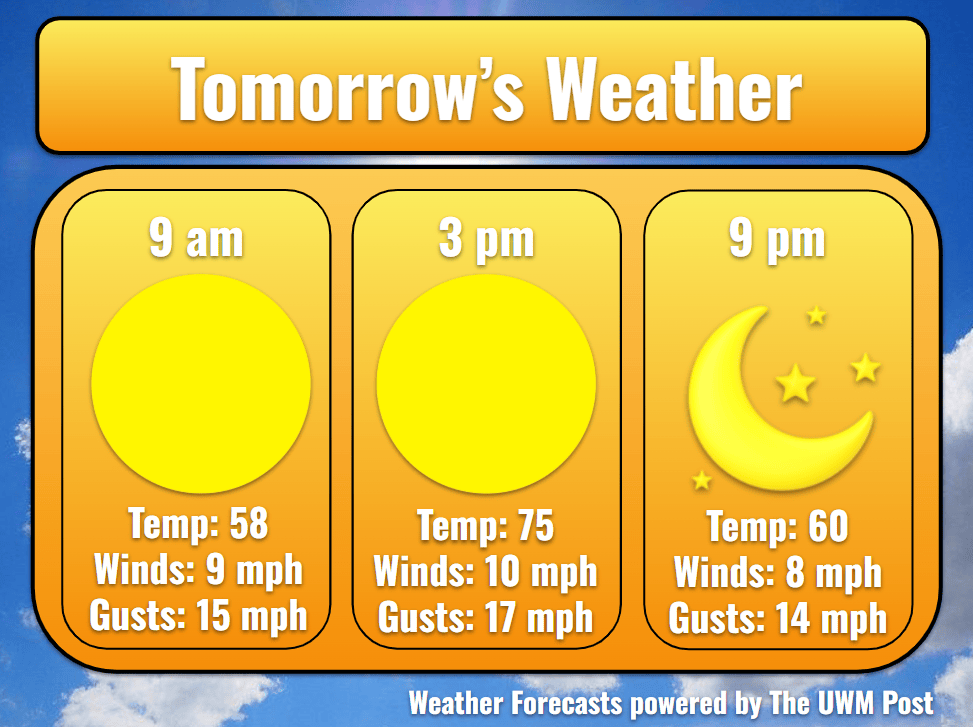
Tomorrow: Another beautiful day awaits Milwaukee on Sunday. Temperatures rise like Saturday but only reach 75. Still from the south, 11-mph winds bring some slightly cooler temperatures in due to the now-passed hurricane’s rain and proximity. On the flipside, this air also contains extra moisture, sending our dewpoints into the low-60s. Clouds stay away for the time being. In the evening, temperatures once again plummet into the 50s.
Tomorrow Night: Although sitting to our west and helping form clouds, a low-pressure system waits its turn to enter until Monday. Winds have responded to its presence throughout the weekend, but as the system eases, winds ease as well. Overnight, gusts only reach 20 mph. Otherwise, temperatures stay around 58 under partly cloudy skies until the beginning of the work week’s morning commute.
Monday: A partly cloudy sky creates rather pleasant driving conditions for Monday morning, but these clouds increase during the day. Now moving over Wisconsin, the low pressure switches winds to the southwest at 10 mph and gusts of 22 mph. Siezing this opportunity, temperatures launch up to the high-70s once more, topping out at 79. This doesn’t last long though, as drizzles enter Wisconsin and swing from the northwest to southeast. Entering in the late evening of Monday, drizzles persist until midnight. Another, more potent round of showers follow Tuesday morning. Ultimately, Milwaukee should only see around a tenth inch of rain. Furthermore, during the night, winds begin to turn to the northwest. Temperatures bottom out at 58.
Tuesday: After spotty morning showers, Tuesday clears up and enjoys calmer winds of 8 mph. Gusts rarely exceed 20 mph. Reflecting the cooler air shoved in upon the wind, temperatures only top out at 66. In the night, we hit a low of 54 underneath some scattered clouds. Beyond Tuesday, models become a bit inconsistent for two reasons. Firstly, all disagree on the intensification of a low-pressure near Alaska. This impacts our upper-level winds down the line, especially for Thursday’s system. Secondly, a low pressure over Southern California potentially becomes cutoff from upper-level wind tracks, increasing the variability of its future path.
Wednesday: Still a day away from impacting Milwaukee, the two upper-level wind features meet over the Rockies and interact. Dependent on if the low over the Gulf of Alaska is strong or weak, the track of the low in the Southern United States either deepens fast or slow, respectively. Wednesday, however, revels in partly cloudy skies and a high of 60. Winds of 7 mph from the northeast continue shipping in cold air across Lake Michigan. We reach a low of 55 while winds turn to the east.
Thursday: With a little bit warmer air pushed in upon the 6-mph winds, temperatures get up to 64 by the afternoon. Overcast skies overtake Thursday, especially in the evening. Even though models agree that Thursday holds rain for Milwaukee, none agree on the timing. Currently, expect the rain to track through in the evening and continue until Friday morning. Accumulation should be within a half inch of rain, but this likely will change. Stay tuned for updated forecasts!
Friday: As winds ramp up from the northwest overnight, temperatures likely fall into the late morning of Friday. Bottoming out at 51, we finally see a bit of sun in the afternoon, sending us back up to 57 for a high on Friday. Winds dramatically increase to 13 mph with gusts exceeding 30 mph, so stay careful if travelling. Upon this wind, cooler temperatures rush in, sending our low down to 41 by Saturday morning. Stay tuned as this unfolds over the week!